Why Fuel Planning on the Loop Is Different
Fuel planning for the Great Loop has shifted noticeably with all the bad advice flying around — most of it written by people who’ve only done coastal hops, not 6,000-mile inland passages. As someone who nearly ran a 42-foot trawler bone-dry between Demopolis, Alabama and the next fuel dock, I spent months getting comfortable with this subject. Today, I will share it all with you.
But what is a “Great Loop fuel problem,” exactly? In essence, it’s the gap between how trawler skippers think about range and how the Loop actually works. But it’s much more than that. You’re not hopping between marinas with diesel pumps every 30 miles like you would on the Chesapeake. You’re threading through rivers, lakes, and canals where fuel docks sit 80 or 100 miles apart — sometimes more. Marinas close seasonally without posting updates anywhere you’d actually look. A dock that ran on barge delivery all summer might be padlocked from November through March. A marina you planned on might have flipped ownership and quietly stopped selling diesel.
The stakes are real. Running dry on the Chesapeake? Call TowBoatUS, pay somewhere around $3,000, get towed in, feel embarrassed. Running dry on the Tenn-Tom Waterway in July? You’re anchored in an oxbow, running your genset around the clock, watching your fresh water disappear, and your schedule collapses entirely. That’s a different kind of bad day.
Displacement trawlers burn 3 to 5 gallons per hour at cruise — not 15 or 20 like a planing boat. That efficiency is genuinely great. It also breeds overconfidence. Skippers assume their range is so comfortable that fuel planning is basically optional. Then they hit a closed marina, a dock that ran dry, or a four-day weather hold at anchor, and that “500-mile range” starts looking uncomfortably short.
Calculate Your True Cruising Range Before You Leave the Dock
Quick callout up front. Once the formula clicks, the anxiety mostly disappears.
Start with usable tank capacity — not the gross volume on your spec sheet. Apply the 80 percent rule. A 500-gallon tank gives you 400 gallons of usable fuel. The remaining 100 gallons sits as emergency reserve, accounting for sump fuel that won’t pump and the practical reality that you’ll never drain a tank completely without consequences.
Next, find your actual consumption rate at cruise RPM. This is the number skippers guess at constantly. Don’t guess. Run a test leg — minimum 4 hours at your intended RPM, typically 1,200 to 1,400 for displacement hulls targeting 7 to 9 knots. Fill the tank completely before you leave. Motor at steady RPM. Refuel at the end and do the division: gallons burned divided by hours run. That’s your real gallons per hour. Write it down.
Here’s an example using real numbers:
- Tank capacity: 500 gallons
- Usable fuel: 400 gallons (80%)
- Cruise RPM: 1,300
- Consumption: 4 GPH (typical for a 38–42 foot displacement trawler)
- Cruise speed: 7.5 knots
The math: 400 gallons ÷ 4 GPH = 100 hours of run time. Then 100 hours × 7.5 knots = 750 nautical miles of theoretical range.
Now cut that by 30 percent. Non-negotiable. Your practical range drops to 525 nautical miles. Wind slows you. River current pushes against you. You idle through lock chambers. You detour around shoals. You’ll make none of your legs under perfect conditions — not on the Loop, anyway. That 30 percent buffer is what keeps you off the radio asking for a tow.
Write that final number on a laminated card. Tape it to your pilothouse wall. That number is your decision point for every fuel stop.
The Scarce Fuel Legs Every Looper Must Know
Not all stretches of the Loop are created equal — not even close. Some regions have diesel every 20 miles. Others have gaps that will genuinely stress your range math.
The Tenn-Tom Waterway deserves special attention. Running south from the Tennessee River toward Mobile, Alabama, you’ll face 60-mile stretches between fuel stops — and the marinas that do exist often keep strange hours. Some shutter entirely in winter. I spoke with three skippers in 2022 who pulled up to planned fuel docks and found them locked and dark. No notice. No phone message. Just a locked gate.
Lake Huron’s North Channel presents a different problem. The summer season is short, volumes are low, and fuel infrastructure is sparse as a result. Plan for 70-mile legs between stops. If weather pins you at anchor, the nearest marina might be 30 miles back or 40 miles forward — neither direction is free.
The Trent-Severn Waterway in Ontario has solid infrastructure, but lock schedules compress everything. No motoring at night. Locks close around 5 p.m. You anchor, you burn generator fuel, you sit — and then you burn extra fuel pushing your schedule the next day to recover. That’s what makes the Trent-Severn endearing to us trawler skippers who like a puzzle, but it plays havoc with fuel budgets.
The Gulf ICW between Carrabelle and Apalachicola, Florida, is notoriously patchy. One marina closed for renovations. Another has diesel but no water. A third sells fuel only on weekdays, 8 a.m. to noon. I’m apparently the type who finds this charming in retrospect and miserable in the moment.
Your best defense: ActiveCaptain for the overview, then actually call the marina. Ask if they have diesel. Ask what days they’re open. Ask cash or credit. A five-minute call on a Tuesday morning eliminates hours of stress on a Friday afternoon.
How Generator and Anchor Time Eats Into Your Fuel Budget
Displacement hull skippers fixate on propulsion fuel — how much we burn moving through water. That’s the obvious number. Stationary consumption is the one that ambushes you.
A 6.5 kW genset — standard on most 40-foot trawlers — burns roughly 0.6 to 0.8 GPH at half load. Run it for 24 hours and you’ve consumed 14 to 19 gallons. Not for making miles. For air conditioning and keeping your battery bank healthy.
A three-day weather hold is now a 42 to 57 gallon event. Not catastrophic on a 500-gallon trawler — until you arrive at that weather window with 120 gallons remaining. Then the math gets uncomfortable fast.
I made this exact mistake in 2020, anchored near Beaufort, North Carolina. A weather system stalled offshore. I ran the genset freely — comfort, battery charging, the usual routine. By day two I’d burned 35 gallons. Still fine, I thought — 140 gallons left. Then I learned the next fuel dock southbound was closed for inventory. I backtracked 12 miles to another marina, burning fuel in the wrong direction. Steer clear of where I went wrong.
Track genset hours separately from engine hours. Before you anchor anywhere known for weather holds, add a genset consumption estimate to your fuel budget. Ask: “If I sit here for three days, what does that cost me?” Then plan your fuel stop accordingly.
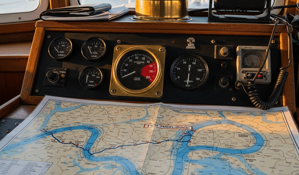
Building a Fuel Stop Plan Using Waterway Guide and Google Maps
So, without further ado, let’s dive in — because the process itself is straightforward. Once you do it once, it takes about 90 minutes per 500-mile section.
Pull up a recent Waterway Guide or the ActiveCaptain database. Mark every fuel dock on your planned route. Color-code them: green for confirmed year-round operations, yellow for seasonal, red for spotty hours or shaky reputation. Don’t skip the color coding — you’ll thank yourself at 6 a.m. when you’re tired and trying to make a call quickly.
Open Google Maps. Measure the distance between consecutive fuel stops. Write each number on your chart or a simple spreadsheet — dock name, distance from previous stop, notes from your phone call. Do this for the entire planned route before you leave home.
Compare every leg distance against your practical range. If your conservative range is 525 nautical miles and a given leg runs 480 nautical miles, you’re fine — 92 percent of range with a small cushion. If a leg runs 550 nautical miles, you cannot make it on one tank. Full stop.
Flag every leg that exceeds 80 percent of your range. Your options from there: split it into two segments with an overnight anchorage in between, identify an off-route marina as a contingency, or shift your departure date to dodge weather that might spike consumption. While you won’t need to replicate the planning process of a shipping company, you will need a handful of tools — Waterway Guide, ActiveCaptain, a spreadsheet, and a phone.
Call every marina on your critical legs directly. Confirm diesel. Confirm hours on your specific arrival day. Ask about their refueling process — some want you on the radio before you enter the channel. Note it all. Update your chart as you get new information.
[X] might be the best option for your contingency dock, as the Loop requires real flexibility. That is because conditions change faster than any database updates — a call made Thursday for a Saturday arrival is worth ten entries in any app.
The Great Loop is entirely doable for trawler skippers. The fuel math isn’t complicated. It just requires a pencil, honest numbers, and 90 minutes of planning before you cast off. That investment pays off across every single mile of the Loop.

Stay in the loop
Get the latest passage maker mag updates delivered to your inbox.